kanpur: master-planning study
the city and the river: speculating growth and the need to re-establish the relationship
Images & drawings courtesy archohm
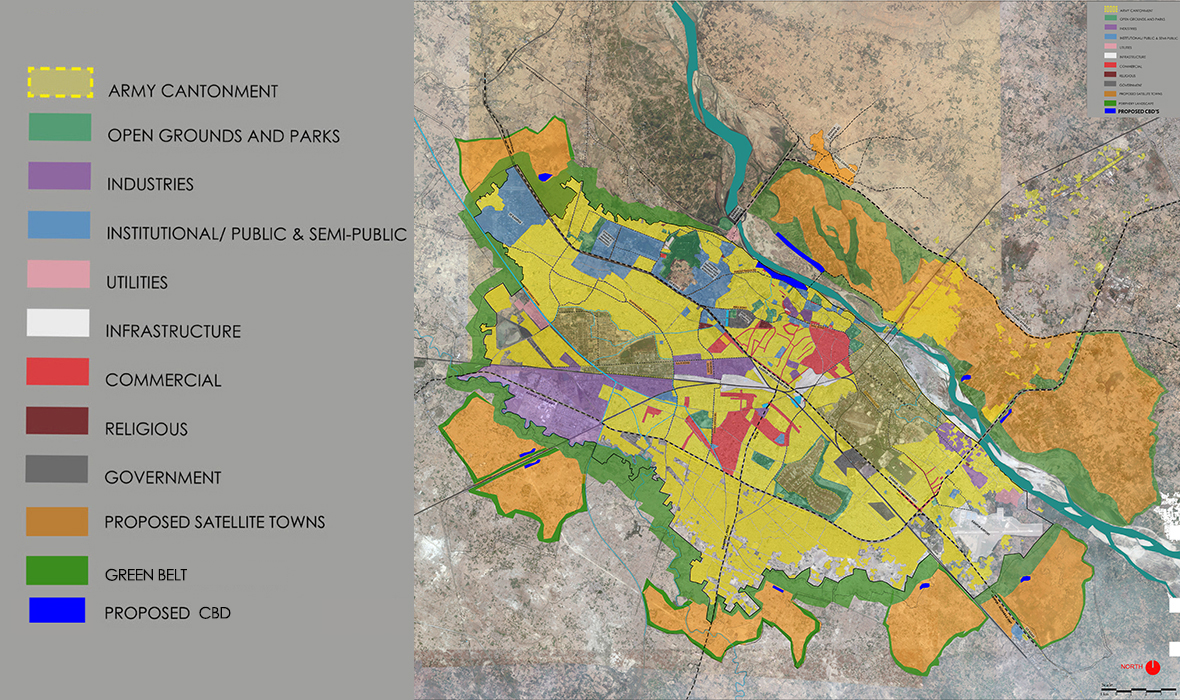
This linear industrial town has its major mobility corridors, railway line and National Highway cutting along the middle, parallel to the river. This makes the city’s relationship to the riverfront rather convoluted and it suffers. All new establishments/ developments seek connection to the roads and hence face their back to the Ganga. The entire city is jarred with heavy traffic moving right through the middle throughout the day & night. Its response to surface & waste drainage is upside-down as the former is interrupted by the highways & railway, the latter (approximately 62% of untreated sewage and 90% industrial effluent) is discharged directly into the river.
KRFD (Kanpur Riverfront Development) is the opportunity of addressing most of the above mentioned problems in addition to providing respite from the high scarcity of green public spaces. Archohm, which was awarded the consultancy to design the riverfront, sought to extend this opportunity by deliberating on the growth of the city and proposing a sustainable trajectory, which is necessary to pay attention to rather than pinning all hopes and desires of emancipation on the KRFD. Prof. Utpal Sharma was invited to conduct a two-day workshop speculating on a sensible urban growth pattern for Kanpur.
The proposal intends to counter the urban sprawl by containing the present boundary within a generous, no-development greenbelt. New satellite developments should be carried out in small pockets beyond the green belt and each satellite should be hemmed in by its own green buffers. Majority of the future new development should be carried out across the river. This may prove to be an administrative challenge which can only be addressed by the political of the state as the area across the Ganga falls in Unnao district; however, it is necessary to bring the river back into the center of the city, the focus of sustainable development.
river front development
River edge settlements are vibrant thresholds. They are hot beds of diversities: geographies – land, water, vegetation and animals – and civilizations – trade, religion, politics and culture.
The emphasis of the project’s program and design is rejuvenation: of degrading real estate, built forms and infrastructure, of the ecology with respect to the terrain and water, of economic opportunities and better housing, and of culture and heritage. The project identifies cultural, heritage and environmental markers and proposes strategies of their restoration and rejuvenation such that they are reintegrated into the life of Kanpur, informing its choices for the future.
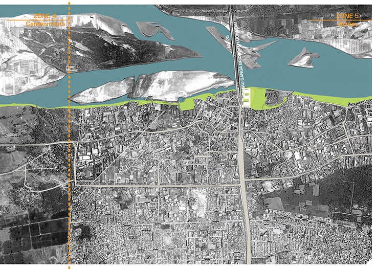
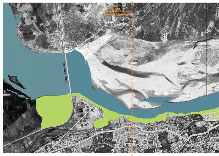
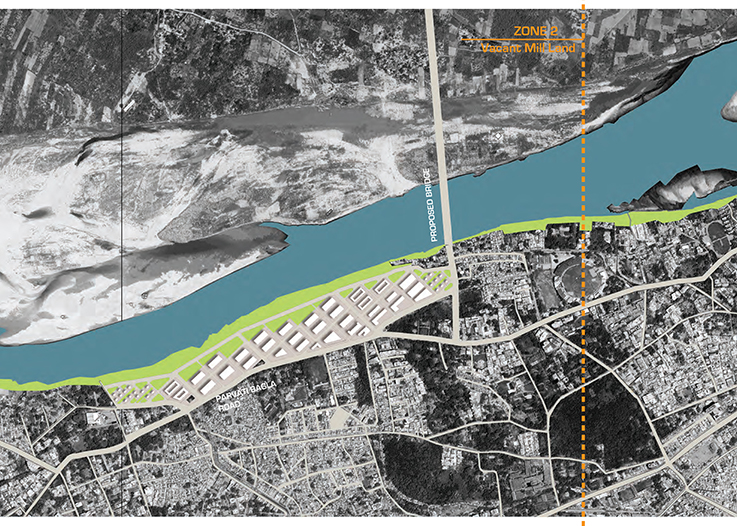
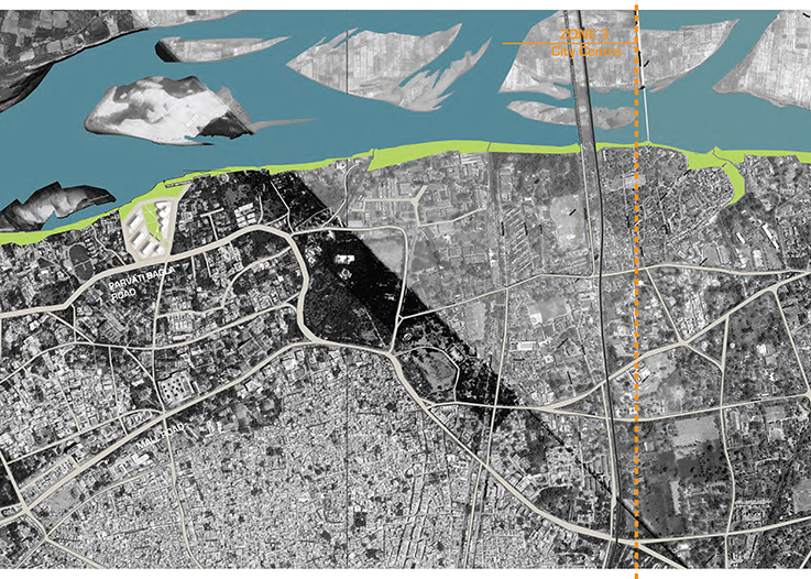
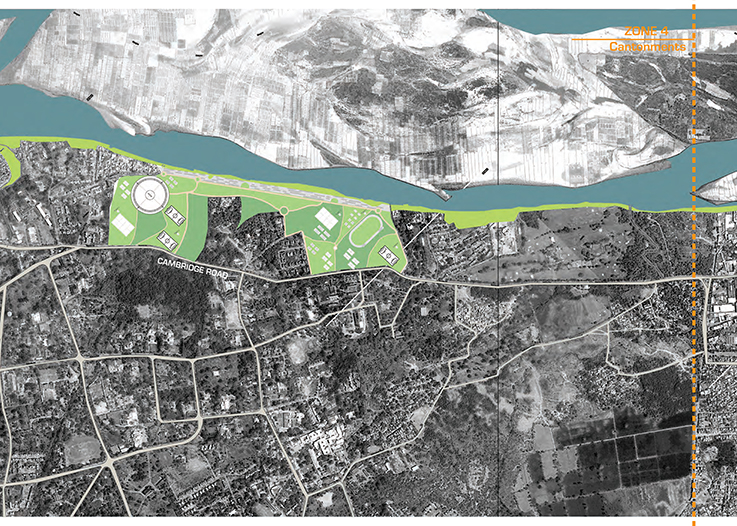
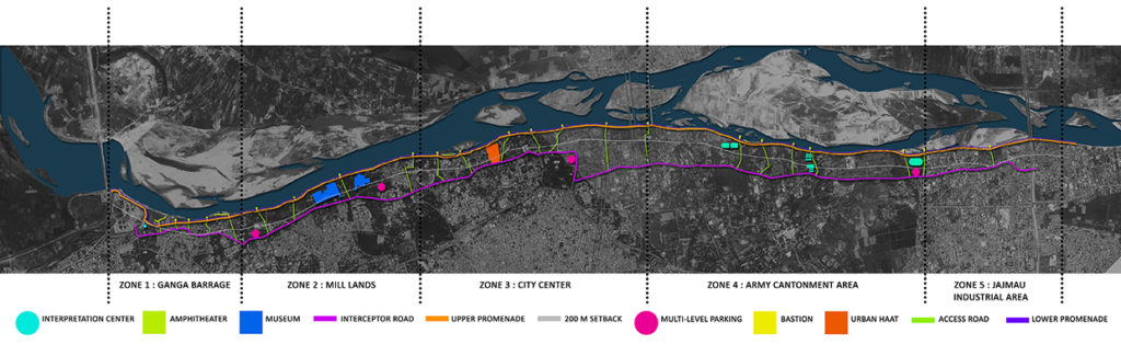
The macro design strategy involves categorizing the city’s 13Km river edge into five zones. Zone 1: Ganga Barrage & Zone 5: Jajmau are the shortest stretches of about a kilometer each.
The latter is a proposed extension of the original scope of the project in order to include the archaeological mound into the development and reinforce its agenda of revitalization. It would, however, pose substantial challenge owing to the density of industrial establishments and slums in the area. Zone 1 was intended as the pilot stretch for detailing for its relative undeveloped and uninhabited nature. Zone 4: Cantonment is the longest stretch and is proposed to include substantial sports facilities as development without compromising on its open & green character. Zone 3, although relatively long, is already saturated, leaving only the scope of redeveloping the jail into housing & commercial real estate.Zone 2 offers the maximum potential for redevelopment necessitating the acquisition of defunct Mill Land or partnering with owners. One of the largest drains of the city discharges into the Ganga through this area.
Developing it as a swamp, creating a large bio-filter offers not only a big opportunity of discharging the city’s waste sustainably, but it could also offer a wonderful canvas for evolving an ecologically sensitive & economically profitable built environment.
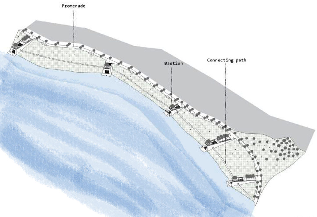
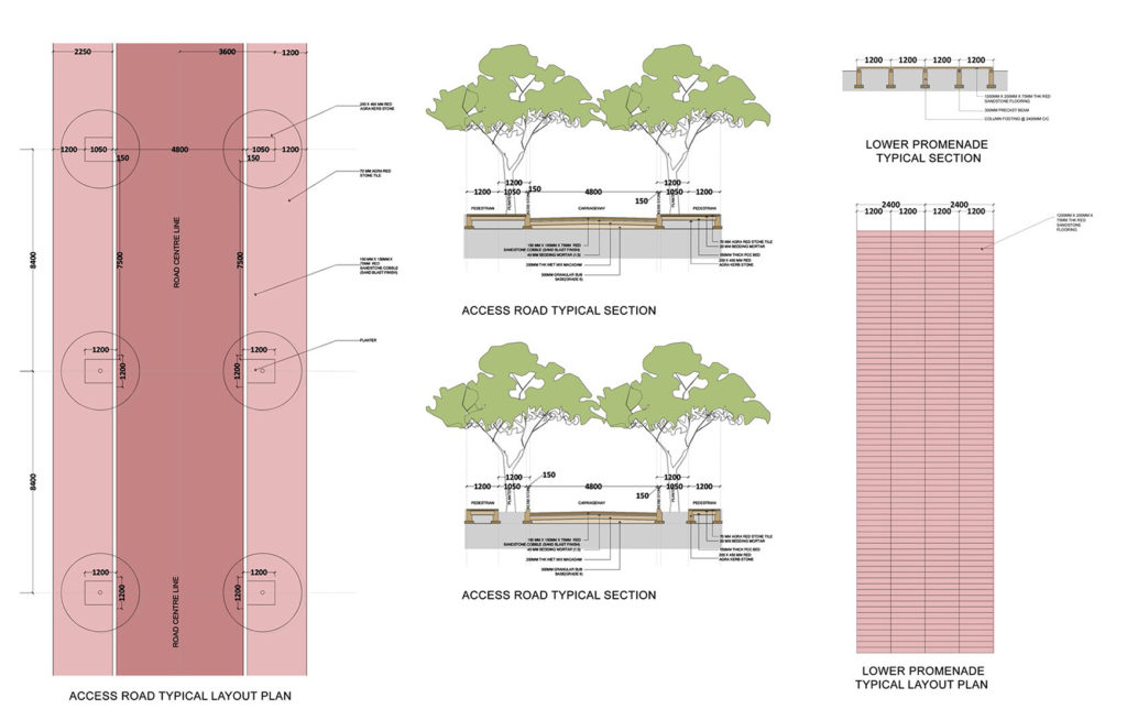
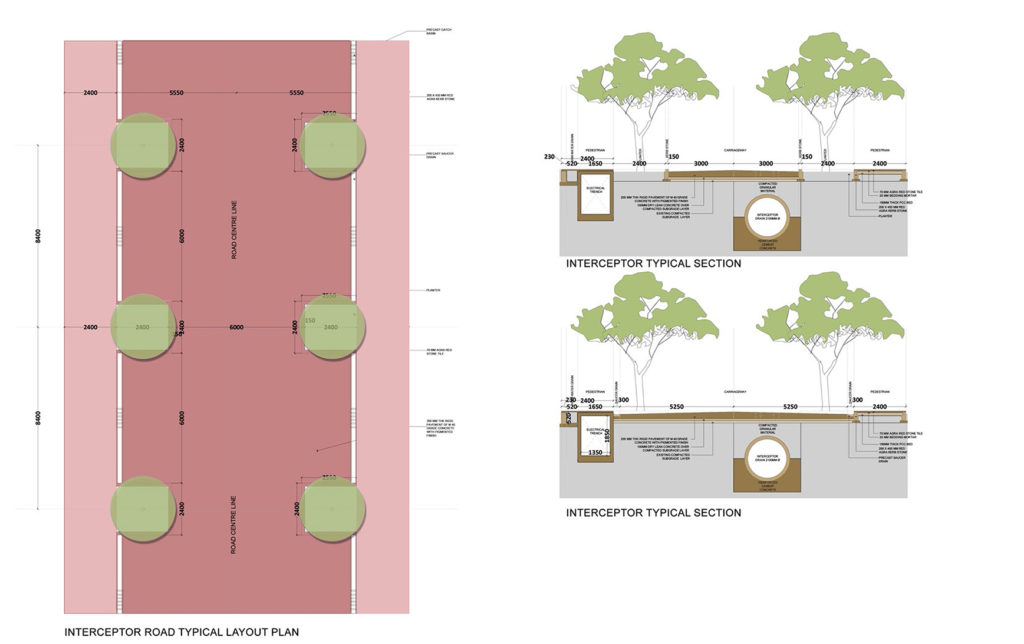
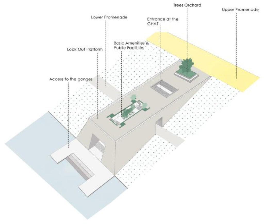
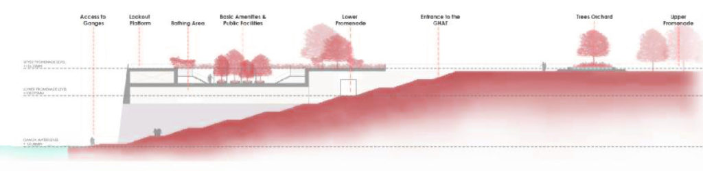
Two pedestrian arteries – a generous upper promenade and a gentle lower one – and a vehicular thoroughfare – 18M wide in most places; constricted to12M in some – seam through the entire length of the river front. An interceptor drain below the carriageway is intended to keep any waste from flowing directly into the Ganga by pumping the sewage to treatment plants. These seams, as long as the city of Kanpur, are punctuated at regular intervals by public amenities and institutions such as access roads, museums, interpretations centers, multi-level car-parks, bastions, ghats & a haat; providing the residents and guests of Kanpur access to nature, community and history.
drawings
 malkum